ملخص
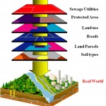
استخدمت GIS في الدول المتقدمة في النصف الثاني من القرن الماضي،وهي برنامج حاسوبي له القدرة العالية على استخدام معلومات وبيانات وصفية وكمية ،وتنظيمها وإدخالها وتحليلها وإخراجها بإشكال مختلفة وخزنها،وقد تطورت تلك النظم بمرور الزمن مع تطور أجهزة الحاسوب،وقد أدى تطور برامجيات تلك إلى اتساع نطاق استخدامها في مجالات الحياة المختلفة،وقد أدى استعمالها في الدراسات الحضرية الى أحداث ثورة نوعية لاستخدامها في المجالين التخطيطي والإداري،مما ساهم في حل كثير من المشاكل التي تعاني منها المدن،ومن ثم رفع كفاءة أداء وظائفها المختلفة،ومن أهم المجالات التي استخدمت فيها النظم في المدن ما يأتي:
1 – تحديد موقع الأنشطة والخدمات في المدينة والطرق المؤدية إليها.
2 – ربط البيانات التعدادية التخطيطية بالمواقع المكانية في المدينة.
3 — إدارة الأراضي في المدينة من خلال قاعدة بيانات خاصة بذلك.
4 — استخدام نظم في توزيع استعمالات الأرض في المناطق الحضرية وتطورها بمرور الزمن
5 — إدارة خدمات البنى التحتية (ماء — كهرباء — مياه الصرف الصحي — الغاز — الطرق)
6 – استخدامها في الدفاع المدني ورفع مستوى أداء واجباته
7 — تحليل نطاق الخدمات المجتمعية والأنشطة في المدينة
8 — تحديد اتجاهات التوسع المستقبلي للمدينة
The use of GIS in planning and managing cities
GIS used in developed countries in the second half of the last century, a computer system has a great ability to absorb large amounts of data and quantitative and qualitative information, organize, analyze and retrieve it in various forms and storage, have seen these systems evolved considerably over time with the development of computer hardware, which increased the scope used in various fields of life, has been used in studies of urban revolution in the sophistication of its progress in this area, where it was used in the fields of planning, management, therefore, have contributed to improve the performance of services and functions of cities,
The main areas where the systems used in the field of urban studies are:
1 – location of activities and services in the city and the roads leading to it.
2 – Census data binding sites of spatial planning in the city.
3 – Management of land in the city through a database to it.
4 – Use GIS in urban land use and development over time
5 – Management of infrastructure services (water – electricity – sewage – gas – roads)
6 – Civil Defense Department and upgrading the performance of his duties
7 – Analysis of the scope of community services and activities in the city>
8 – to identify trends in the future expansion of the city
 English
  Français
  العربية


