Home
About us
Contact
English
Français
العربية
Home
About us
Evaluation Committee
Publishing Guide
Research
Events
Books and letters
Books
Contact
Sort
Recent
Most Commented
Random
Published Researches
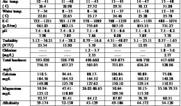
INVESTIGATION OF SOME HEAVY METALS IN TOW PLANTS OF DRINKING WATER ON BABYLON PROVINCE,IRAQ.
by Ali Neji
0
Full Review »
Published Researches
Relationship between Soil Physico-chemical Properties and the Spectral Reflectance’s of Some Soil Sites from Arbil Governorate
by Ali Neji
0
Full Review »
Published Researches
Control of a Hybrid Wind-PV and Energy Storage System
Control of a Hybrid Wind-PV and Energy Storage System Mohammed Al Busaidi, Amer Al-Hinai*, Rashid Al-Abri, Mohammed Al-Badi Electrical & Computer Engineering, Sultan Qaboos University, Oman Abstract—Distributed energy gen...
by Lamouchi Helmi
0
Full Story »
Published Researches
The Development of Iraqi Datum for Building GIS database
by Ali Neji
0
Full Review »
Published Researches
Comparative responses to cadmium toxicity of Arabidopsis thaliana mutant seedling (cad2) and wild type (col0)
Comparative responses to cadmium toxicity of Arabidopsis thaliana mutant seedling (cad2) and wild type (col0) CHAFFEI HAOUARI CHIRAZ1, SLATNI TARAK2, DJEMAL FATMA1, GOUIA HOUDA1 (Company / Faculté des Sciences de Tunis) 1Unive...
by Lamouchi Helmi
0
Full Story »
Published Researches
CHANGE DETECTION IN HOUR-IBN NAJAM / MIDDLE OF IRAQ BY USING WATER INDEX (W.I) ALGBRA
by Ali Neji
0
Full Review »
Published Researches
Determine the morphostructure phenomenon, East Khor Al-Zubair by Space Imageries
Dr.TorhanAlmofti * Ahmed Ibrahim Saleh Al-Naemi** Abstract Through the use of satellite data taken by the Landsat satellites a color phenomenon was...
by Lamouchi Helmi
0
Full Story »
Published Researches
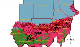
Monitoring Desert Creeping Disaster in Sudan
by Lamouchi Helmi
0
Full Review »
Published Researches
Geospatial and multi-criteria analysis to rank suitable sites of shallow aquifer recharge with reclaimed water: Application to Nabeul – Hammamet groundwater
by Ali Neji
0
Full Review »
Page 3 of 8
‹ Previous
1
2
3
4
5
6
Next ›
Last »
The Latest
News
Articles and Interviews
Reporting Geo-sp
Published Researches
International Conference on Social and Human Sciences
Precision Technologies Role in the Study of Climate Change Impact
5th International Conference on Water, Energy, Food and Agricultural Technology Istanbul, Turkey, 22-25 January 2019
Bluesky’s LiDAR experts educate Mouchel’s water industry professionals
Creation of a digital 3-dimensional model
AeroMetric Announces New High Accuracy Mapping Solution
Interview with George Gartner
Measuring earth’s vital magnetic field
Selecting Suitable Sites for Wind Energy harvesting in Iraq using GIS Techniques
Machine Learning and Statically for Evaluating the Classification of Medical and Lab Services
Study the characteristics and nature of the Indian dates tree. Tamarindus Indica L In the southwestern region (Jizan and Asir)
More »
More »
More »
More »
 English
  Français
  العربية