Abstract
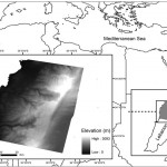
The quality of digital terrain models is most often evaluated in terms of absolute location accuracy. However, many DTM users need information about landforms and hydrography, which are described by the derivatives of the elevation (slope, aspect, curvature) rather than by the elevation itself. The problem is that elevation accuracy does not provide quantitative information on slope accuracy without considering the spatial autocorrelation of the elevation error. Some experiments are presented in this research to show how slope quality can be evaluated to characterize the geomorphological quality of an elevation data set. A DTM generated by stereo correlation of SPOT images over a mountainous area of Lebanon is compared with field surveys at different spatial scales. The effect of scale on slope accuracy is demonstrated and analysed.
 English
  Français
  العربية


